|
|
|
|
|
|
übersetzt von Jürgen Heyn
|
||||||||
|
MAP PROJECTION PROPERTIES: |
EIGENSCHAFTEN VON KARTENPROJEKTIONEN
|
||||||||
|
The original document is available: If this link doesn't work, try here |
Das Originaldokument ist
verfügbar: Wenn dieser Verweis nicht funktioniert, hier versuchen
|
||||||||
3.1.5 Gall-Peters equal area projectionPeters published his controversial map in 1972, convening a press conference at Bonn in 1973 for as many as 350 reporters. One year later, he gave another lecture in Berlin on his map to the German Cartographical Society where he compared his map with a dozen other well known map projections. He then reviewed different cylindrical equal area map projections, with standard parallels ranging from 30° to 55° of latitude (Loxton 1985). |
3.1.5 Gall-Peters
flächentreue Projektion
Peters veröffentlichte seine umstrittene Karte 1972 und berief 1973 eine Pressekonferenz mit etwa 350 Journalisten in Bonn ein . Ein Jahr später hielt er erneut einen Vortrag, diesmal vor der Deutschen Kartographischen Gesellschaft in Berlin, in dem er seine Karte mit einem Dutzend anderer bekannter Kartenprojektionen verglich. Schließlich wiederholte er verschiedene flächentreue Zylinderprojektionen mit Standard-Breitengraden von 30° bis 55° (Loxton 1985).
|
||||||||
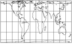
| The Peters equal-area representation of the world should rather be called "Gall's Ortographic projection", since it is the same projection Gall developed in 1885. Peters has heavily promoted "his" projection in spite of repeated statement in the cartographical literature stressing the lack of novelty (Snyder 1993). The Gall-Peters' projection is a secant cylindrical projection with standard parallels at ±45° (see Figure 3.5). | Die Peters flächentreue Darstellung der Welt sollte besser "Gall's Orthographic Projection" genannt werden, weil es sich um die gleiche Projektion handelt, die Gall 1885 entwickelt hat. Peters hat trotz wiederholter Aussagen in der kartographischen Literatur über den Mangel an Neuem, für "seine" Projektion sehr geworben (Snyder 1993). Die Gall-Peters Projektion ist eine Sekanten-Zylinderprojektion mit dem Standard-Breitengrad bei ±45° (siehe Abb. 3.5). | ||||||||
|
Fig 3.5. The Gall-Peters' projection centered on Greenwich. 30° graticule. Standard parallels at ± 45°. Note the distortion in the polar areas. |
Abb. 3.5. Die Gall-Peters
Projektion auf Standard-Längengrad Greenich. 30° Unterteilung.
|
||||||||
|
It can be imagined that one standard line can be obtained by approaching the standard lines progressively to 0º of latitude, accordingly to the formula here below (Decleir 1980). |
Gemäß der unten aufgeführten Formel kann man sich vorstellen, zu einer einzigen Standardlinie zu gelangen, indem man die Standard Linien vorlaufend gegen den 0° Breitengrad verringert (Decleir 1980).
|
||||||||
|
|
||||||||
DistortionThe selection of standard parallels at that latitude leads to an enormous stretching of the Equatorial areas: the bounding rectangles of equal area are increasingly compressed East-West and elongated North-South with the internal shapes correspondingly squeezed and stretched (Robinson 1985). By definition, an equal-area projection should give the possibility of comparing areas of different landmasses. The shape and angular deformations in the higher latitudes are so great that it becomes almost impossible to identify countries in these latitudes. |
Verzerrung Die Wahl dieses Standard-Breitengrades führt zu einer enormen Streckung der äquatorialen Gebiete: ein flächentreues, die Fläche umschließendes Rechteck wird zunehmend in Ostwest Richtung zusammengedrückt und in Nordsüd Richtung gestreckt, welches entsprechend für die enthaltenen Formen gilt. (Robinson 1985). Nach der Definition soll eine flächentreue Projektion den Vergleich von Flächen zwischen verschiedenen Landmassen gewährleisten. Die Verzerrung von Form und Winkeln in höheren Breitengraden ist so groß, dass es fast unmöglich ist die Länder der höheren Breitengrade zu erkennen.
|
||||||||
|
Discussion Peters adopted the promotional strategy of first asserting that Mercator's projection became the basis of the global map that formulated man's concept of the world; the projection was overused for whatever kind of purposes other than navigation. There he is definitely right. But Mercator himself never developed his map for other purposes than navigation (Snyder 1993). Balthasart (1935) already give some comments in favor of the Gall orthographic projection. He pointed out that during the early twentieth century, the Mercator projection was still very popular, even for display purposes that require the equal-area property. Since on both projections the meridians and parallels cross at right angle and hence form a perpendicular network, and since the main directions can easily be identified, the equal-area projection should prevail. |
Diskussion Peters gestaltete seine Werbestrategie indem er zuerst behauptete, dass die Mercatorkarte die globale Grundlage für das menschliche Weltbild sei; die Projektion ist für jeglichen Zweck ungeeignet außer zur Navigation. Damit hat er unbestritten recht. Aber Mercator hat seine Karte niemals zu einem anderen Zweck als der Navigation entworfen (Snyder 1993). Bereits Balthasart (1935) äußerte sich wohlwollend über die Gall's Orthographic Projection. Er führte aus, dass zu Beginn des 19. Jahrhunderts die Mercatorkarte sehr verbreitet war und auch zu Zwecken verwendet wurde, die eigentlich die Eigenschaft der Flächentreue hätten haben sollen. Da sich in beiden Projektionen Längen- und Breitengrade im Winkel von 90° schneiden ergibt sich ein rechtwinkliges Gradnetz; und da sich die Haupthimmelsrichtungen leicht erkennen lassen, sollte die flächentreue Projektion den Vorzug erhalten.
|
||||||||
| Peters stated that Mercator's projection remains highly influential in "shaping" people's view of the world: most of us, if asked to draw a map of the world from memory would roughly reproduce the Mercator's projection (Kaiser 1987). He also pointed out that the Mercator projection had the capacity to represent constant bearing angles as straight lines, but that this property was not applicable in the Polar areas since the poles themselves can not be represented (Loxton 1985). He finally added that the Mercator's projection was the only available map of the world, that it is euro-centered, that third world countries are shown disproportionately smaller in area than those in high latitudes, and that we need an equal area map to challenge our attitudes and prejudices. | Peters
sagte, dass die Mercatorkarte immer noch einen großen Einfluss auf
die Ansicht des menschlichen Weltbildes hätte: Die meisten von uns,
wenn sie gebeten würden eine Karte aus dem Gedächtnis zu zeichnen,
würden annähernd eine Mercatorprojektion wiedergeben. Er führte
weiter aus, dass auf der Mercatorkarte Linien konstanten Kurses
Geraden sind, aber dass diese Eigenschaft in den Polargebieten nicht
zutrifft, da die Pole selbst nicht dargestellt werden können. Letztlich
fügte er noch hinzu, dass die Mercatorkarte die einzige sei, die
euro-zentrisch ist, und die Länder der dritten Welt
unverhältnismäßig verkleinert dargestellt werden, als die Länder
in höheren Breitengraden, und daher brauchen wir eine flächentreue
Karte um unsere Ansichten und Einschätzungen zu überdenken.
|
||||||||
| Unexpectedly many volume users like the United Nations, school and colleges, churches and Third World action have adopted this projection. Peters claimed that his projection is the only correct representation of the world and that all other projections should be removed from atlases and other school atlases (Kaiser 1987). Although most GIS applications can be projected with Peters, this projection, like the Lambert equal-area should be disregarded. Equal-area cylindrical projections distort shapes too excessively; hence the message the map is meant to communicate is lost. | Unerwartet
viele große Nutzer wie die Vereinten Nationen, Schulen und
Universitäten, Kirchen und Dritte Welt Organisationen haben sich
diese Projektion zu eigen gemacht. Peters behauptet, dass diese
Projektion die einzige korrekte Darstellung der Welt sei, und dass
alle anderen Projektionen aus Atlanten und Schulatlanten entfernt
werden sollten. Trotzdem viele GIS Anwendungen die Peters Projektion
unterstützen, sollte diese, wie die Lambert flächentreue
Projektion, ignoriert werden Da flächentreue Zylinderprojektionen
die Formen zu stark verzerren geht das kommunikative Wesen der Karte
verloren.
|
||||||||
|
End of original document |
Ende des Dokumentes |
||||||||
|
Comments / Anmerkungen von Jürgen Heyn
|
|||||||||
| Eric Delmelle lists at the end of his document the references that he used. No publication of Arno Peters is listed. | Eric Delmelle führt am Ende seines Dokumentes die verwendeten Quellen auf. Es befindet sich keine Veröffentlichung von Arno Peters in dieser Liste. | ||||||||
Request to publish and translate this document:
Von: "Jürgen HEYN" <j.heyn@gmx.de>
An: <delmelle@geog.buffalo.edu>
Betreff: Your dissertation: Map Projection Properties
Datum: Montag, 10. Februar 2003 21:10
Ref.: www.geog.buffalo.edu/~delmelle/thesis/thesis.doc
Dear Eric Delmelle,
as my hobby I am working on a dissertation about the difference between the equal area projection of Rev. James Gall and the method of construction created by Arno Peters.
On the internet I found the above mentioned document:
MAP PROJECTION PROPERTIES:
CONSIDERATIONS FOR SMALL-SCALE GIS APPLICATIONS
by Eric M. Delmelle
Although there seems to be no copyright on this document I think it is more than fair to ask for permission to publish and translate chapter 3.1.5 of this document to German
language. My document will consist of a table with two columns. On the left side the original
(unchanged!) English text and on the right the German translation. So everybody who is able to speak English will be able to directly compare my translation with your original text.
My dissertation will be as objective as possible with no judgement of anybodies
opinion. It will be a private and non-commercial presentation.
Attached you will find a *.zip archive of the document (in *.html format) which I intend to publish on my
homepage.
I would greatly appreciate any support that you could provide.
Thank you very much in advance.
I am looking forward to hear from you soon.
Best regards
Juergen Heyn, Wilhelmshaven, Germany
Von: "eric delmelle" <delmelle@geog.buffalo.edu>
An: "Jürgen HEYN" <j.heyn@gmx.de>
Betreff: comments
Datum: Mittwoch, 12. Februar 2003 21:39
Hi Jurgen
Sorry for the late answer
I corrected 2-3 things in the .html paper (in light blue you will see) and
I also attached a paper I wrote 2 years ago on the Peters phenomenon.
Altough my english was very "poor" at that time, the paper contains main
ideas and good references at the book you may find useful
Hope this will help you
--eric
------------------------------------------------------------
Home: 61 College Street, Buffalo, NY 14201, USA
Phone: (716) 882-6302 CELL: (716) 983-2038
Office: Department of Geography, UB, Buffalo, NY 14261, USA
Fax: (716) 645-2329
------------------------------------------------------------