|
|
|
|
|
||
|
|||
|
HOW to LIE with MAPS Mark Monmonier The University of Chicago Press |
HOW to LIE with MAPS Mark Monmonier The University of Chicago Press
|
||
|
Maps
for Political Propaganda page 96-98 ... Yet
in the early 1970s this subtle and probably unwitting geopolitical
propaganda served as a convenient straw man for German historian
Arno Peters, who published a "new" world map based on an
equal-area projection similar to one described in 1855 by the
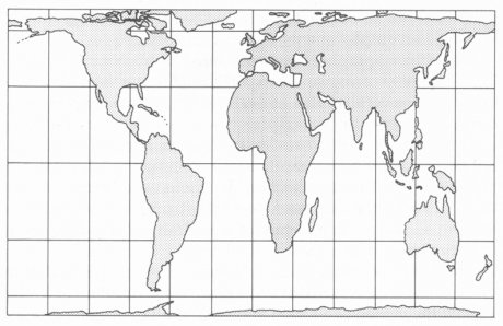
Reverend James Gall, a Scottish clergyman. As figure 7.7 shows, the
Gall-Peters projection gives tropical continents a mildly attenuated,
stretched look, which probably explains why geographers and
cartographers have adopted more plausible equal-area maps and why
the basic texts on map projections Peters consulted had ignored
Gall's contribution. Indeed, Lambert and other cartographers had
developed numerous equal-area map projections, including many that
distorted shape much less severely than does the Gall-Peters version.
FIGURE 7.7. The Peters projection or, more accurately, the Gall-Peters projection.
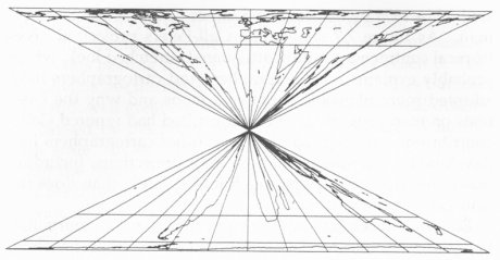
FIGURE
7.8. Like all equal-area projections, this hourglass equal-area map
projection John Snyder devised as a joke has area fidelity but
distorts shape. They
also published
large and small versions of the Peters projection, hung it on their
walls, and used it in their press releases and publications. Perhaps
because journalists also like to champion the oppressed and can't
resist a good fight, the press repeated Peters's claims and reported
the success of his bandwagon. Academic cartographers became both
puzzled and enraged puzzled that the media and such prominent,
respected institutions could be so gullible and ignorant, and
enraged that these groups not only so persistently repeated Peters's
preposterous assertions but so obstinately refused to look at
cartography's writings, accomplishments, and rich history.
... |
Karten für politische
Propaganda Seite 96 ff.
... Noch in den frühen 1970er Jahren diente diese raffinierte und vermutlich unbewusste geopolitische Propaganda als Wegbereiter für den deutschen Historiker Arno Peters, der eine "neue" Weltkarte auf Grundlage einer flächentreuen Projektion veröffentlichte, die ähnlich der war, die der schottischer Geistliche Reverend James Gall 1855 beschrieben hatte. Wie Abbildung 7.7 zeigt, gibt die Gall-Peters Projektion den tropischen Kontinenten ein schwach gestrecktes Aussehen. Das erklärt möglicherweise, warum sich Geographen und Kartographen eher glaubhaftere, flächentreue Projektionen zu eigen machten und warum in den Quellen die Peters zu Rate zog, Gall keine Erwähnung fand. Tatsächlich hatten Lambert und andere Kartographen mehrere flächentreue Kartenprojektionen entwickelt, einschließlich vieler, die die Formen viel weniger schwerwiegend verzerren, als es die Gall-Peters Version tut. Aber Dr. Peters wusste Massen zu beeinflussen. Ein Journalist und Historiker mit einer Doktorarbeit über politische Propaganda. Peters berief eine Pressekonferenz ein, um Mercators Abbildung der Welt (sowie alle nicht rechtwinkligen Projektionen) zu verdammen und für seine eigene Projektion mit der "flächentreuen" oder genauer "gleichwertigen" Darstellung der Welt zu werben. Er lenkte die Aufmerksamkeit auf Mercators beleidigende Darstellung der meisten Länder der dritten Welt und beschuldigte die Entwicklung in der Kartographie des Stillstandes. Peters traf den richtigen Ton beim Weltkirchenrat, der lutherischen Kirche von Amerika und den verschiedenen Organisationen der Vereinten Nationen. Religiöse und internationale Entwicklungsorganisationen begrüßten Peters und seine "neue Kartographie," die größere Gerechtigkeit und Genauigkeit versprach.
Abbildung 7.7 Die Peters Projektion oder genauer, die Gall-Peters Projektion.
Abbildung 7.8 Wie alle flächentreuen Projektionen bewahrt auch diese Karte in Sanduhrenform, von John P. Snyder als Scherz entwickelt, die Flächentreue verzerrt aber die Form. Sie veröffentlichten große und kleine Versionen der Peters-Karte, hingen sie an ihre Wände und verwendete sie bei ihren Pressemitteilungen und Veröffentlichungen. Vielleicht auch weil Journalisten sich gerne für die Unterdrückten einsetzten und einen guten Kampf niemals scheuen, wiederholte die Presse Peters Behauptungen und berichtete über seinen Erfolg. Akademische Kartographen waren ratlos und wütend, dass die Medien und solche berühmten und angesehenen Institutionen so leichtgläubig und ignorant waren, die grotesken Behauptungen von Peters zu wiederholen und sich eben diese Gruppen aber beharrlich weigerten, sich die Schriften, Leistungen und die umfassende Geschichte der Kartographie anzusehen. Nicht alle Kartographen verloren den Sinn für Humor. Der Kartographieexperte des US Bundesamtes für Geologie und Rohstoffe John P. Snyder, selbst Erfinder einiger nützlicher und auch fortschrittlicher Kartenprojektionen, bot seinen kartographischen Kollegen eine weitere flächentreue Projektion an, um zu zeigen, dass eine flächentreue Karte nicht unbedingt eine gute Karte sein muss. Abbildung 7.8, Snyders flächentreue Projektion in Form einer Sanduhr bewahrt, das was die Peters-Karte tut und die Mercatorkarte nicht tut, die Flächentreue. Aber es zeigt ebenso deutlich, das Flächentreue nicht Formtreue bedeutet. ... |
||
|
End of quotation |
Ende des Zitats |
||
|
Comments by / Anmerkungen von Jürgen Heyn |
|||
|
Mark Monmonier recommends at the end of his book some further readings. No publication of Arno Peters is listed.
MONMONIER, Mark: Eins zu einer Million. Die Tricks und Lügen der Kartographen. |
Mark Monmonier gibt am Ende seines Buches einige Empfehlungen für weiterführende Literatur. Es ist keine Veröffentlichung von Arno Peters aufgeführt. Das Buch "How to lie with maps" ist auch in deutscher Sprache erschienen: MONMONIER, Mark: Eins zu einer Million. Die Tricks und Lügen der Kartographen. |
||


Von: "Jürgen HEYN" <j.heyn@gmx.de>
An: <publicity@press.uchicago.edu>
Betreff: Permission for translation
Datum: Donnerstag, 13. Februar 2003 20:28
Ladies and gentlemen,
I would like to extract 3 paragraphs from the book:
"How to lie with maps", by Mark Monmonier, second edition 1996
and translate it to German language.
I would appreciate if you could send me an e-mail address of an authorized person.
Thank you very much in advance.
Best regards
Jürgen Heyn, Wilhelmshaven, Germany
Von: "Perry Cartwright" <pcc@press.uchicago.edu>
An: =?iso-8859-1?Q?Jürgen?= HEYN <j.heyn@gmx.de>
Betreff: Re: Fwd: Permission for translation
Datum: Freitag, 14. Februar 2003 17:28
Dear Jürgen Heyn,
For permission send a conventional letter (no e-mail) with full details to
me at the address below.
Perry Cartwright
Manager, Contracts & Subsidiary Rights
University of Chicago Press
1427 East 60th Street
Chicago, IL 60637
(773) 702 6096
(773) 702 9756 FAX
Von: "Jürgen HEYN" <j.heyn@gmx.de>
An: <mon2ier@syr.edu>
Betreff: Request permission
Datum: Freitag, 14. Februar 2003 10:56
Dear Mr. Monmonier,
I am a professional helicopter pilot with the subject of map projections as my hobby. I am working on a dissertation about the difference between the equal area projections of Rev. James Gall (1885) and Arno Peters (1967).
It will be published on my private homepage shortly.
As a literature reference I would like to publish 3 paragraphs from your book "How to lie with maps" starting page 96, which I translated to German language. It consists of a table with two columns. On the left side your original (unchanged!) text and on the right the German translation. So everybody who is able to speak English will be able to directly compare the original with my translation. At the end I made some comments. Please see the attached *.zip archive how I intend to present this document.
I would greatly appreciate if you would give special permission for my intentions.
I know that this book has already been translated to German language by Doris Gerstner. Unfortunately I am not able to get this book. If you have a copy and if you insist, I will take the "official approved" translation from Mrs. Gerstner. (In this case please send me a copy of the respective paragraphs.)
Please let me point out a few things:
My homepage www.heliheyn.de is a pure private internet presentation with absolutely no commercial intentions. I will not evaluate any message associated with the Peters-Map except the mathematical formulas of projection. I will not criticise or interpret anything that you have written regarding the Peters-Map. It is just to show as an example of a declining position against the Peters-Map which you share with many others.
I would appreciate if could permit my above mentioned request.
Best regards
Jürgen Heyn
PS: In the near future I would like to publish and translate Chapter 1 (The Peters Projection Controversy) of your book "Drawing the line". If you have any objections please let me
know.
Von: "Mark Monmonier" <Mon2ier@maxwell.syr.edu>
An: "Jürgen HEYN" <j.heyn@gmx.de>
Betreff: RE: Request permission
Datum: Freitag, 14. Februar 2003 14:45
Dear Mr. Heyn,
The University of Chicago Press controls the copyright, so they'd be the proper organization to grant permission. If they agree, I have no objection.
I looked at your Web site, and am puzzled that you seem to see the issue of world map projections as largely a matter of Peters or Mercator. The latter has long been recognized as unsuitable for thematic or general reference maps, and there are many others that are superior to the Peters map. That said, maps can be quite robust, and the Peters map is probably not as dysfunctional as many would have us believe.
Best,
MM
Mark Monmonier, Department of Geography, Maxwell School of Citizenship and Public Affairs, 144A Eggers Hall, Syracuse University, Syracuse, NY 13244-1020, U.S.A.
mon2ier@syr.edu; http://www.maxwell.syr.edu/geo/Monmonier.htm
http://markmonmonier.com
(315) 443-2605 [secretary] / 443-5641 [direct] / 443-4227 [fax] / 446-1508 [home]
"Democracies die behind closed doors," 6th Federal Court of Appeals, in Detroit Free Press v. Ashcroft